Saturday, October 8, 2011

Hike 6 of 47 - Chelan Riverfront trail and REACH 1 Trail - a combo walk/hike

Hike 6 of 47  Chelan Riverfront Trail & REACH 1 Trail


The last weekend of September several of us were at the Washington State Nurses Association Leadership Conference in Lake Chelan, WA. Conferences of this type, any nursing conference for that matter, seems to keep attendees busy from morning until late evening, but I was hopeful that I could get a hike or two in. Besides, there is food galore at these things and a lot of time spent sitting on your butt.  Julie & I searched the fabulous Washington Trails Association website and other places  on line and in some hiking books and came up with a plan to to the Chelan Butte trail on Sunday morning.  We were up bright and early, directions in hand, with the intent to hike this 5 mile trail and be back in plenty of time to get ready for the days conference events. The day was shaping up to be a nice, sunny day and we decided to do the Chelan Butte hike. The book, "Day Hiking Central Cascades" gave great directions, however we found it difficult to find the "forested gully" where we were supposed to park and begin our walk up the service road. There was lots of "gully", but not so much "forest".  Once we came to the sign that said "Northwest Forest Pass Required", we figured that we were close. However, continuing to follow the very bumpy, washed out gravel road we ended up at the top, so we parked and walked around a bit. The views were amazing over both sides, with Lake Chelan to one side and the river and farmlands to the other. It was quite windy, and therefore dusty, up there.


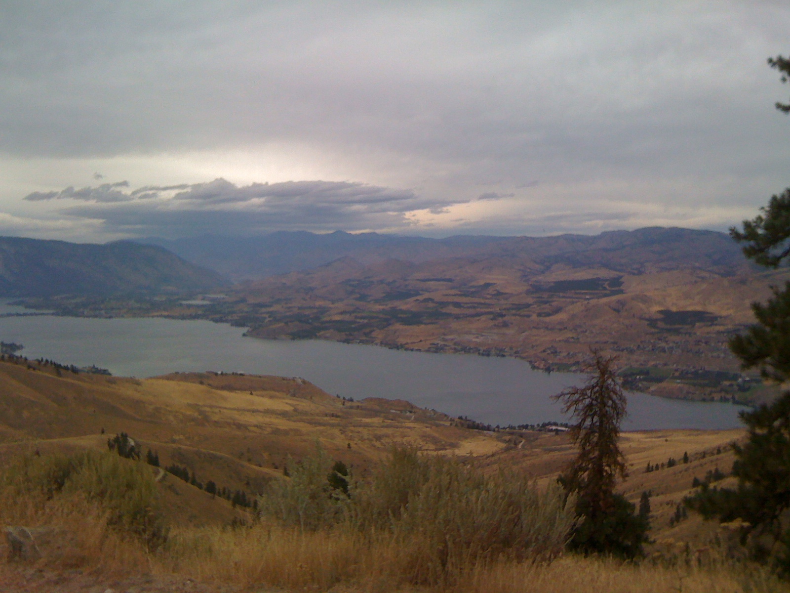
Lake Chelan from Chelan Butte


Apparently it's a spot for hang gliders to launch from, although we didn't see any. Although the views were amazing,it wasn't really my favorite kind of place to hike. I think vehicles with low clearance would have a difficult drive over parts of this service road. There were deep washouts and large rocks jutting up from the roadway. I worried a bit about my oil pan and driving off the cliff!  I was glad to see a turn around spot at the top because I REALLY didn't want to back down the entire service road.  I was saddened to see the amount of litter up there, too. Friends that were also at the conference said they've found a way to hike up to the Butte without having to utilize the service road, however we didn't have time to check those trails out, maybe another time. I think Spring would be the best season for this hike.

So, we got back to our room and decided to take a different approach; we'd just walk the Chelan Riverfront trail instead. This approximately 1 mile loop follows the beautiful Chelan River as it leaves Lake Chelan. The water is crystal clear and we saw many ducks and geese along the way. Once we got onto this path and just before crossing over the bridge to head back to Campbells Resort , we found signs for the REACH 1 trail. Not sure where it lead or how long it was, we followed it. It lead us along some neighborhood sidewalks, through some older parts of town and eventually to a new parking lot with great interpretative signs. I perused the signs and determined that it would be approximately 5 miles round trip, and that we would get us back to our conference with plenty of time to shower and get prepared. We hit the paved trail which eventually became gravel and wound it's way down through what appeared to be a recently burned area. There are benches with more signs along the way. Once down at the level of the river, we could see Chelan Butte from where we were. Along the way, we could see many remnants of burned out items such as cars, refrigerators and old metal Coleman coolers. I wonder why this wasn't cleaned up when this trail was built? Isn't that the kind of work that prisoners should do?


View from the REACH 1 trail, jut below Chelan Dam
The day was heating up and we hadn't planned on taking this hike, so we didn't have any water with us. All we had was our cameras, cell phones and room keys. The river water was crystal clear. We stood for a while and watched the water cascade over the dam. It seemed like a great place to wet my shirt to cool off. I couldn't help myself. I apologize to anyone who lives up on  the hillside who happened to be outside drinking their morning coffee.  


A great spot for dunking ones shirt

It was a nice hike with lots of good ecological info on the interpretive signs. I enjoyed it, but I think I'm just fond of the green, wet side of the state. Dusty desert doesn't interest me, but the river and lake views are beautiful. This little hike was much nicer than the Chelan Butte adventure. 

Campbells Resort also offers some great views, too! It's my favorite place to stay while in Chelan. I can't wait to come over here with my family. I think there would be something fun for everyone. 
Can't beat the view from our room.

 I will try more later. Right now, it's time for a shower and a nap before work. 

In a couple of weeks, I'm headed to Vermont. I'm excited to be able to get some miles on the Appalachian Trail while I'm there. Should be fun!
.

Distance: 5 leisurely miles


Thursday, September 29, 2011

Hike 5 of 47 - Peshastin Pinnacles


On our way back from Washington State Nurses Association Leadership Conference in Lake Chelan where we stayed at Campbell's Resort, we decided to stop at Peshastin Pinnacles State Park 10 miles west of Wenatchee right off Highway 2, thinking it would be a good place to use the potty and stretch our legs. I had planned this stop for our trip over to cross one of the hikes off of my list, but it worked out that it was dusk when we passed the area, so I just figured we'd stop on the way back. While I knew this desert-y state park was little at just over 34 acres, I was really interested in seeing the unique sandstone formations that are frequently used by climbers.

From the Washington State Parks website:

"The park is named for its "pinnacles," or unique sandstone formations, and for the town of Peshastin, located three miles away. The area has been popular for rock climbing since the 1960s. In 1986, land owners closed the pinnacles to climbers for liability reasons. Later, The Trust for Public Land, a non-profit group, purchased and developed the site, then sold it to State Parks."

Photo of Peshastin Pinnacles State Park
From the Washington State Parks website.

The four of us arrived at Peshastin Pinnacles State Park in the heat of the day, around 3 p.m.....naturally! The park is located off Highway 2, about 10 miles west of Wenatchee, it is well signed so just follow the signs from Highway 2. It's less than 1 mile off of the highway, a great place to stop for a break. The morning before we left Lake Chelan, I had read some trip reports for this hike and found that some hikers suggested that this wasn't a good hike for little kids, or those not steady on their feet; I would wholeheartedly agree. There are so many great hikes in our state, if you are looking for something fun to do outside, check out the Washington Trail Association website. It's very interactive and has something for everyone.

We figured it would be a good potty stop as well as a place to stretch our legs on our ride home. It was HOT and therefore the privy was LESS THAN PLEASANT! In fact, being anywhere near it was less than pleasant. I'd guess it was about 85 degrees out. I knew from reading a hiking book that there was a 1.5 mile loop that was recommended and looked interesting. While it only had 400' of elevation gain, those 400' were gained quickly!  Once parked, we left Jeannie in the car with the keys in case she wanted to turn the air conditioning back on. Since she recently had knee surgery, she wasn't up for this hike. Our intention was to stop at the privy and then head up the trail. One whiff in the mid day heat and I went directly to the trail. After crossing the parking lot, with a quick glance at the trail map on the bulletin board we headed up a service road (for the stinky privy, I'm sure), we passed through this gate and onto the trails.
From the parking lot, you must pass through this gate to get to the trails.
Linda and I had our cameras, so we stopped frequently to both catch our breath and snap a few photos while Julie motored on ahead of us. Since this was a sort of spontaneous stop, we weren't really dressed for the occasion. I had regular tennis shoes since my suitcase containing my hiking shoes was packed deeply in the back of my car. Poor Linda was in jeans, a long sleeve T-shirt and also her regular tennies, having just changed out of her sandals at the last minute. Thankfully she did!  Julie had on her trail runners, so she was best equipped on the sandy trails.
You can see the trail switchback up next to this crazy sandstone rock.

Apparently people DO climb these things. Is it wrong to say I'm glad they weren't there when we were there? I would have been worried to death about them! Our co-worker Doug, who was also attended the conference we had just come from, told us that he climbs here, too. 


What a view! This is from about 100' above the trail head.

On just about each switchback, Linda and I stopped for two reasons; to catch our breath and take some pictures. While you can't see the Wenatchee River in this shot, it was beautiful, as were the orchards.


About 1/2 way up we came across these plants. The pods reminded me of a mustache. Linda touched one and said they were soft and squishy. I certainly don't know what kind of plant they are, but I wonder if the flowers are amazing?
Does anyone know what this plant is? These seed pods were soft and squishy.

When we reached the top, the views were amazing. We could see the river as it snaked its' way east.  We could hear people talking, but I think it was the field workers in the orchards off to our right from the picture above. We could also see Jeannie who had gotten out of the car and was waving her arms. I had seen a car come in to the parking lot and then leave again, and being the "worrier" of the group, I hollered down to her a few times "Are you okay?"  She kept waving her arms and finally replied that she was and we headed to the north side of the summit to find the trail down and back around the the south side. Our intent was to make a loop.  This park is small, and I think that no matter what trails you explored, it would not be difficult to find your way back to the trail head and parking lot.

From the back (north) side of the summit, we could see a Tee Pee

Apparently a lot of rock climbers enjoy
climbing here in this state park.
From the top, when we looked north the views were also amazing; more sandstone, more orchards, more hills and a tee pee. I'm not sure why it was there....but it was cool sitting up there. I'm usually a fan of hiking amongst the big trees, enjoying the coolness of their canopy's, but this was a very interesting and beautiful hike, too. We headed down the back/south side on what looked like a trail that may or may not take us where we wanted to go. My only concern was getting down to the bottom only to find that we had to climb all the way back up again to find the right trail. But, we got about half way down, climbed back up the side of a hill and around the the front/north side where we could see Jeannie and the car again. 
I couldn't get over the view; AMAZING! The Wenatchee River, pear orchards, the
Enchantment Mountain Range....beautiful! Can you see my car down there?


Only I could be outside for less than an hour
 and get a sunburn. Check out the amazing sandstone.
The trails were quite narrow at times, and walking in the slippery sand made for some unstable footing for must of the time. Often we had to straddle the center of the narrow trail to avoid the ankle-twisting gullies obviously made by water coursing its way down the trail. I was so proud of Linda, who hadn't been hiking in quite a while. At times, usually in spots where the trail was narrow or when she turned the corners of the switchbacks or when she stopped to take a photo, she felt a little vertigo, especially when the trail got more narrow. I would hold on to her belt loop or her hip to stabilize her while she captured her photo. In the photo below, where the trail was a bit wider on our way down the back side, I asked Linda & Julie to just look back at me. Take note of how firmly planted Linda's feet are! ;) Linda hikes at my speed and I think I've found another hiking buddy and we've all talked of getting together for hikes in the near future.


Linda & Julie on the way down, via a traverse on the west side of the hill.
 I love how firmly planted Linda's feet are!

Me, Linda, Julie & Jeannie. I set the camera on a picnic table, set the
timer to 10 seconds and......Voila, we had a group photo.


The three of us were almost to the bottom and we noticed that Jeannie had gotten out of the car and was stopped on the trail. She went about 50' and decided it was too steep. She recalled that I said the trail was "flat"; if I did say that, I was WRONG!  It was quite the steep trail; short but mighty! It would NOT be fun in the rainy weather. I do know that this park closes for the winter on October 15th and reopens in March, which makes sense. Don't let the short distance and small size of this state park fool you; some of these trails are narrow and steep! A fall off the side would not be fun. So, if you venture out to this little park off Highway 2 near the town of Cashmere, hang on to your kids, your dogs and your friends belt loops!  And above all else, watch out for rattle snakes. It was a fun hike, we were the only ones there except for the car that came into the parking lot and left again. Perhaps that was due to it being a weekday, or hot; who knows the reason. I'd like to spend more time here and explore all the trails. I LOVED knowing that I wouldn't get lost. Next year on the way to the same conference, I'll be sure and stop here again.  Enjoy!

My Rating:  ***/5
Distance:  1.5 miles
Elevation Gain:  400'
Time:  55 minutes


Monday, September 26, 2011

Hike 4 of 47 - Yellow Aster Butte

September 7, 2011


Yellow Aster Butte Summary


Julie, Jean and I left Mount Vernon just before 8:00 a.m. Until last evening, Julie & I were going up to Heliotrope Ridge, however the Glacier Public Service Center in Glacier, WA was kind enough to give me some information about creeks that would have to be forded, how deep and swift they were running, etc. They let me know, in no uncertain terms, that the snow bridge was no longer a safe crossing. There was a low log crossing a little downstream, but they were not sure that it would still be above water for our return crossing due to our HOT weather and all the snow melt.  Sooooooo, we opted to go up to Yellow Aster Butte instead. I must keep reminding myself that this adventure is supposed to be fun, not dangerous!  Besides, I really didn't want to get my new hiking shoes wet, ;)

We left Mount Vernon just before 8 a.m. and headed north on Highway 9 (took the scenic route!) and then east on Highway 542. Wow, what a beautiful drive! We stopped at the Glacier Public Service Center which was built in the early 1900's. We stretched our legs, utilized the restrooms and gathered some trail info. Here there was a GIGANTIC slab of a tree that is estimated to be 730 years old and I HAD to get my picture taken with it...it was AMAZING!
Me & a big tree!

About 13 miles past the town of Glacier, we took a left on Forest Service Road 3065. Up we went, approximately 5 bumpy, dusty, washed out miles through the forest on a one lane road. When we reached the trail head right at 10 a.m., there were already about 6 cars there and it was WARM! Honestly, I'm surprised some of those little cars had the clearance to make it up that road. A word of caution: If you have a car that is low to the ground, head up this road with great caution. If we had continued on up this FS road, we would have come to the Twin Lakes trail head.

Once parked, we were immediately and viciously ATTACKED by black flys the moment we opened the car doors. What horrible, pesky little creatures! Thousands, maybe millions and billions and gazillions of them, all trying to attack us mercilessly. From the moment we stepped out of the car, if we stopped moving, or even just slowed down, they swarmed, attacking every bit of uncovered skin they could find. We all DEET'd ourselves up well in the parking lot and off we went. Jean signed us in at the trail register, we all made a pit stop at the pit toilet and we started our way up the trail, trying to escape being eaten alive by the little back flys. The sign at the trail head said that it was 3.6 miles to the Butte. The dusty trail starts out with some moderate switchbacks through tall brush. The trekking poles came in handy to keeping the brush off of your legs. About 1/2 mile in I think the black flys had succeeded in beginning to drive me utterly, completely crazy. I had taken to smacking my own shins repeatedly with my poles, just to get the fly's off of me. The pesky things grabbed hold of clothing and were hard to dislodge, but I found that they succumbed to a good smearing with my hands.... and I didn't even care! I am one who normally takes great lengths to avoid stepping on ants, feels badly if a squirrel runs in front of my car, but the flys.......I took great joy in smashing them while laughing maniacally. 

By this time, Julie was ahead and out of sight. Jean was in front of me, usually on the switchback above me, but I could spot her rounding the bends of the switchbacks.  There were lots of big old trees that were down; they looked like left overs from the logging days.We then entered the coolness of the trees, crossed over several snow patches, tiny creeklets fueled by the melting snow and many muddy spots on the trail. The new hiking shoes gave excellent traction and kept my feet dry, too.

We entered the Mount Baker Wilderness area and the trail leveled out some. We crossed a few small snow patches and snow bridges, where it appeared that the snow that was left about about 15" deep.


In one direction we had great views of Mount Shuksan and the other gave Mount Baker a chance to shine!

Mount Shuksan


A peak at Mount Baker


Eventually we climbed a steeper part of the trail that opened up into a meadow filled with wildflowers. Beautiful yellows, whites, reds and purples filled the area, as did the buzzing of busy bees. Fortunately, we left the black flys behind. From here, we looked left and Mount Baker seemed to fill the sky. What an amazing sight that was!


Lupines
More lupines


Jean headed back across the traverse


Mount Baker in the background


When we got back to the parking area, it was 95 degrees in the car! The black flys continued to be relentless, although I was happy to see that there were many dead on my dash board.  There were a couple of "Forest Rangers" in the parking lot, as well. I chatted with one of them for a moment, he asked me about our hike, I asked what he thought the temperature was and then he wandered off to speak with his buddy who was approaching in a Jeep. We loaded up into the car, tried to shoo out the flys that made it inside the car and headed down the dirt road, back to Highway 542. Upon leaving the parking area, we passed the "Forest Rangers", who turned out to be Border Patrol agents. They were apparently waiting for someone they were expecting in the area. Coming from southern California, the Border Patrol were a common sight where I'm from. I guess they knew who they were looking for!

On our way back home, we stopped at Grahams Store in Glacier and stocked up on some snacks. I opted for salty cashews and chips, while others had ice cream, a shake and other treats.

All in all it was a beautiful hike. It was quite a drive, 72 miles each way, so I wish we could have gotten two hikes done during that trip out Highway 542.  I certainly could have done without the evil black fly's. The trekking poles were quite helpful, especially across the large snowfield, which I unfortunately did not get a picture of. I definitely recommend this hike. Try to get there on a day when the black fly's are in town doing their shopping or something else that takes them away from the trail. Did I mention that they were HORRENDOUS?


Miles:  6
Calories: 2,480
     Time: 5 hours

Friday, September 9, 2011

Hike 3 of 47 - Oyster Dome

September 5, 2011

Oyster Dome is a hike I hadn't done in the past, but I wanted to and everyone that had done it said that the views are AMAZING! So, off I went. Julie and I planned to meet up at Rhododendron Cafe at 8:30 on Labor Day so that I could get back home in time for work. The weather was supposed to be beautiful and I was looking forward to the hike!

This hike starts out on Highway 11 at about Mile Post 10, just about 5 miles south of the Fragrance Lake trail head. Another similarity....a few steep switchbacks from the get go. This 6.5 mile round trip boasts 1,900 feet of elevation gain and is a guaranteed cardio workout.  About one mile into the trail, you are rewarded for your efforts at a small viewpoint. Once you wipe the sweat from your eyes, there are views of Lummi, Samish, Guemes, Cypress, Fidalgo, Orcas and several other islands of the San Juan Archipelago. On a clear day, one can see all the way out to the Olympics. Just amazing...Here is one critter that was enjoying the view from the viewpoint.  

Admiring the view

At the bottom you are greeted by a couple of signs for the Pacific Northwest Trail (PNT), and you continue on the PNT for about 1.5 miles before parting ways. The PNT, which goes from Glacier National Park in Montana to the Olympic Coast, seemed to be well marked in this area, complete with the white blazes painted on trees, which is more than can be said for other trails leading off the main trail. Some signs are what people have written with a Magic Marker or by hanging a rubber glove on a branch with a finger pointing to what you HOPE is the right way. On a scale of 1 to 10, for signage I would give this trail a 2. In fact, on the way back down, we did get lost for about 1/3 of a mile, and we weren't the only ones.
Sign at trail head
An informative rock


White blazes indicating the
Pacific Northwest Trail


There were about 4 creeks along the trail to Oyster Dome and 3 of them were dry on Labor Day. I would have loved for them to be wet so that I could soak my bandanna to cool my neck off! At about 2 miles, we started a pretty significant climb that required grabbing on to some branches, rocks and whatever else was handy. Some trail reports that I had read said that "this isn't much of a workout", "not a very difficult hike", however it's enough climb for the entire route up to the top to be rated a Category 1 climb....not too shabby!


The trail was cleaner than some and dirtier than others.  There were several small trash items, including a burned up pair of jeans, the remnants of a sweater, cigarette butts (how someone can smoke while climbing those hills is beyond me) and, worst of all......the left overs from an illegal fire. The smoke smell was strong, but I went over and stuck my hand in it to make sure the ashes were cool, and they were. How sad that someone felt it was okay to start a camp fire in a forest. That could have turned ugly.

Just below Oyster Dome are the Amphitheater Bat Caves. They are reached by taking a marked side trail before reaching Oyster Dome. We didn't venture here; I'll leave that one to the bats.

The trail itself was ankle-twisting rocky and rooty. Roots are generally easy for me to negotiate as they stay mostly still. I found that I spent 80% of my time looking down rather that at the beautiful surroundings. The forest itself didn't boast as much of the BIG trees as the hike on the Fragrance Lake trail, nor does it have much in the way of interesting foliage. But, what this hike lacks for trail side beauty, it makes up with the views from the top. The top is no place for little kids or dogs who aren't leashed or under strict voice control. Oyster Dome is really just a big, bare rock and I personally wouldn't venture out onto the rock if it were rainy or snowy. It would be very easy to fall off the side.

Looking northwest
Julie & I at the top

Anacortes & it's refineries in the middle of the picture,
Olympic Mountains in the distance

After spending some time at the top and snapping a few photos, it was time to head down to get home in time to go to work. About 1/4 mile from the top, we got onto the wrong trail. Almost immediately I began questioning whether we were on the right trail....the creek to the left didn't look familiar, some blow downs didn't look familiar, I didn't remember passing certain pieces of trash on the way up and there was a lot of old cable (which I found very interesting....possibly left over from long-ago logging??), about 1.5 to 2" thick that was laying around, mostly buried. We did pass a small amount of the old cable on the way up, but we were now passing A LOT of it on the way down. My suspicions were confirmed when we reached a large creek that we did not cross on the way to the top. We turned back and ran into some guys who made the same mistake that we did. I got a little worried, because I was cutting it close with the time I needed to get home and get cleaned up for work.  Of all the days to forget my GPS in my car... UGH, that will NEVER happen again!

It took us about 2.5 hours to get to the top and about 2.25 hours to come back down. On our way up, we passed a few other hikers, but on the way down, the trail was darn right busy. While we were coming down, we passed a young couple holding hands, with the guy leading the way and the girl walking behind him. After they passed I remarked "Well, THAT won't last long". I cannot imagine hiking up all 1,900 plus feet of that trail while holding hands with someone. No sense dragging someone else down with me when I fall!

When we passed the viewpoint that was 1 mile from the trail head, it was crowded....standing room only! What a difference a few hours makes. If you are going to do this hike, start early. Parking is very limited and the trail gets quite busy. The trail was dry and dusty  from there on down.

 This cute little "mailbox" greeted us at the bottom. We didn't even notice it when we started out.

Interesting "mailbox" at the trail head

All in all, it was a nice hike. Am I glad I did it? YES. Would I do it again? Probably not, unless I had someone visiting the area and wanted to show them the view. While the view was fantastic, the trail condition wasn't great, nor was their much to look at while on the trail. I would probably like it more when there was some moisture on the trail, to help embed some of those ankle-twisting rocks and keep the dust at bay. But, it was a great workout, at least for me anyway.

Oyster Dome Summary - September 5, 2011

Miles:  6.5
Calories:  1,850
Time:  4.75 hours (which includes getting a little lost)


Saturday, September 3, 2011

Gear!

Gear......to sum it up, it's important! Sore feet, lack of water, hypothermia....these can all ruin a hike....or take your life, if you aren't prepared.  Some people feel like they need to have the best of the best; well, that's pretty subjective to a point.  I say "Buy the very best that you can afford."  Seriously, why go into debt or have to eat Top Ramen for a month, all because you bought what you thought you HAD to have, or what someone else told you that you HAD to have, only to find out it wasn't really the right purchase for YOU?

SHOES
Shoes are important. You won't know just HOW important until you've hiked a few miles in the wrong shoes!  I've hiked in my regular walking shoes which are the Brooks Addiction 9 shoes. I love these shoes for putting on the miles during training for the Susan G Komen 3 Day for the Cure and I wear them during the 60 miles of the event, too.  In fact, I LOVE these so much, I wear them exclusively to work, as well.  They have worked well for me on a very smooth, level  trail. Can I stress anymore how much I love these shoes? When they have run their lifespan, they then become my "working out in the yard" shoes.

Once I started on the more technical trails such as in the Anacortes Community Forest Lands, I found myself falling more often than I'd like. It's not so much the falling that worries me, because bruises and scrapes will heal. It's the bumping my head on a rock or rolling off of a cliff that frighten me!  I knew I needed to invest in some trail shoes.When researching trail shoes, I naturally thought I'd go with the Brooks Cascadia trail shoes, since I love their Addiction 9 running shoes so much. I went up to Fairhaven Runners in Bellingham, WA to spend the gift certificate the hubster had gotten me for our anniversary, and imagine my surprise when I found  that I liked another brand of shoes much better. I ended up getting the Adidas Supernova Riots,  which have pretty much eliminated my falling, except for the occasional tree root or boulder that jumps out at me. So, I'm 100% pleased with these shoes. BTW, I'm usually a major bargain shopper, like I don't want to pay retail price for anything.  Imagine my surprise to find that the Adidas Riots, which were more expensive than the Brooks, were ON CLEARANCE at Fairhaven Runners!  Whoo Hoo! Score!!! 
Adidas Supernova Riot 3

I bought myself a little gift for my birthday. I figured it was time for some hiking shoes. Trail running shoes have a lot of flexibility, while hiking shoes are a bit more sturdy. So, in true Liz form, I did some research and found some hiking shoes I liked; the Garmont Amica hiking shoes. They have a wonderful Vibram sole and lots of built-in stability features, which apparently I need. They are light-weight with water-repellent suede and abrasion-resistant mesh. They have a thicker tongue for a better fit, and a toe kick so your little tootsies don't get demolished and a higher side on the inside of the shoe for added support. Oh, and they are dark grey and aubergine. Aubergine? I never thought I'd wear anything aubergine. Oh well.....I'm excited to give them a try this week. Best news??? 1/2 price at REI!! PS Sale ends September 5th......go on, click the link, you know you want to buy something!!  So, here they are!
Garmont Amica hiking shoe


SOCKS
Avoid cotton like the plague! Buy performance socks, made for the activity you are undertaking. Change your socks when your feet are sweaty. Be kind to your socks and they will be kind to you..  'Nuf said....
HYDRATION
Carrying your water while hiking is must, must, must! Unless.....you have a water filtering system (i.e.pump filter, purifier or tablets) that you  are carrying along with you. Water is essential. If you are trudging through the snow or hiking in the sun, you will probably need even more water than you think.  There are many options for carrying water; water bottles, vests, base layers, hydration packs, etc.  I drink A LOT and I mean A LOT of water, so I carry 3L of water with me in my CamelBak L.U.X.E, regardless of how long I'll be out on a day hike. I figure you can always bring water home, but being lost somewhere without water could be disastrous. And besides, you might get thirsty.

If you are a women, be sure to get a hydration pack specifically designed for women. We need a sternum strap that goes above the girls, not one that squishes them flat....we'll let our sports bras do that. I love that my CamelBak has lots of room for a day hike. I carry snacks, first aid kit, flashlights (2), more snacks, extra socks, camera, emergency Mylar blanket, maps, visor, sunscreen, more snacks, ChapStick, emergency whistle, a trash bag, phone, keys, a waterproof layer, hat & gloves, lunch and much more along with me. My pack, when fully loaded, weighs about 14 lbs. I also take extra precautions and use a carabiner just to keep the zipper pulls together, in case a pocket tries to get jostled open accidentally. Wouldn't want to lose any of my snacks!! I'm convinced that I'm going to get lost and if I do, I'll be able to feed everyone with me....or hog all of the snacks for myself, depending on the kind of mood I'm in.

When shopping for a pack, take your time, try it one, have the clerk load it down, adjust the straps, jog around with it if that's how you will be using it. Be sure to get a good feel for how it fits on your body. That being said, I love my CamelBak. It keeps my hands free to take pictures, put on ChapStick, eat a snack, and most importantly, to catch myself if I fall!  Drink, drink, drink!!! Busy kidneys are happy kidneys.

PS  Hillary reminded me that I forgot to list "pepper spray". It's always in my packs front pocket or my vest pocket in the winter. I've only had to bust it out once when two loose big dogs, (one Lab and one Rottweiler) were circling me on my bike. Fortunately, they ran off with just my  yelling "Get, go home!" and waving my jacket at them.

CamelBak L.U.X.E 3L

TREKKING POLES
I have some New Balance Expert trekking poles that I received for Mothers Day. I haven't used them yet, but I will be using them this coming week. I can imagine how helpful they will be (especially to someone with a falling habit), when fording any creeks or rivers. Mine have adjustable height and built-in shock absorbers. They are supposed to give your arms a good workout, too. I imagine they'd be pretty good for fighting off any misbehaving dogs or wildlife or even naughty people, too.  I'll keep you posted.
New Balance Expert trekking poles

Don't forget a hat and sun glasses! Protect your eyes, you've only got two and they need to last you a long, long time. Especially important around snow and water, which reflect the sun.

That's about all for now.  I'm sure that I have forgotten something. Remember, buy what works for YOU, don't give in to peer pressure. I'd also love to hear what YOUR favorite gear is.

Happy Hiking!

Tuesday, August 30, 2011

Hike 2 of 47 - Fragrance Lake

Fragrance Lake (elev. 1,100') is located in the Chuckanut Mountains, which are reached via Route 11. The Chuckanuts are foothills of the Cascades and the only place where the mountains meet the ocean. The views can be amazing, looking out over Samish Bay, with the San Juan Islands on the horizon.

Sunday morning came a bit too early for me! I knew it would....and it did.   Being an evening shift worker, I'm usually just getting tired around 2:00, falling asleep around 3:00 a.m., and my best sleep occurs between 4:00 and 8:00 a.m., so the thought of getting up and out of the house by 8:00 is enough to make me cringe....and it did. However, I really wanted to be on this trail long before the crowds on what was going to be a beautiful, warm summer day. So, I set my alarm for 7:15 and woke up at 7:10. Most of my gear was waiting by the door, so I got dressed, downed a cup of coffee, loaded up Jack and I was on the road by 7:55. I headed north on I-5 for about 5 miles, and exited at Exit 231 (Route 11-Chuckanut Drive). Within one mile of exiting the freeway, the farm lands were enveloped in a fairly thick fog. As I headed north, the fog seemed to be getting thicker. Naturally, I was hoping it would burn off by the time I trudged my way to the viewpoint on the way to Fragrance Lake.

I was the first car at the small parking lot at the trail head, located just after the entrance to Larrabee State Park. The trail head parking is on the right and holds about 6 or 7 cars. I backed in to make leaving that much easier. Route 11 is a narrow, winding road and backing out onto it on a busy summer weekend could be difficult. I hung my Discover Pass on my rear view mirror, put on my pack and we were off.

My GPS listed this trail head at about 170' elevation. This trail starts with couple steep switchbacks, meets up with the Interurban Trail, I turned right and after about 25' I picked up the Fragrance Lake trail on my left. I climbed and climbed up a series of switchbacks passing a tipped-over tree. It always amazes me how big the root ball is on these trees. Although this tree was only about 3 feet in diameter, look at how big across the roots are.  It's difficult to put into words for others, so I sat Jack in front of it for comparison sake.  He's a good size dog, over 90 lbs and about 2 to 2-1/2 feet tall. Quite impressive...


Jack in front of a tipped-over tree

From the trail head, I climbed for about 40 minutes before reaching a well-marked turn off to a Viewpoint. That's what the sign said "Viewpoint .2 mi".  On this trail, there was one blow-down that took a big step over. Initially I thought that one could prove challenging for little kids, but if they made it up those switchbacks, then that toppled over tree won't be much of a hindrance. Out at the viewpoint was a nice log to rest on, and a split rail fence to (hopefully) keep anyone from falling back down to the roadway. Unfortunately, the marine layer was still resting over Samish Bay. Although beautiful in its own way, I wanted to see the islands and the water. I could see the tip top of some islands poking through the white cloud layer.


Looking west over Samish Bay

We headed back down the Viewpoint trail and turned left on the main trail making our way toward Fragrance Lake. As I came to the main trail, I could hear some women talking, and so did Jack. The trail then began another series of steep switchbacks and the we took a break on a log bench, to let the women catch up and pass us. We passed these amazing "nurse trees"....I just love these trees! 


At least 3 trees growing on top of this downed tree. Isn't nature amazing?


And one tree growing right on top of what's left of what was a GIGANTIC tree.


The lake is another 1.1 miles from the Viewpoint trail. It may just be my imagination, but the second set of switchbacks seems harder than the first set, although the elevation gain is very similar. Perhaps there are fewer switchbacks, I don't know and I didn't have the energy to count them!

Just before reaching the lake we passed through a bike barricade. Fragrance Lake trail is open to hikers only while other trails allow horses and/or mountain bikers. I saw none of either of those.  When we reached the lake, Jack walked into the very clear water and took several long, cool drinks. After he finished quenching his thirst and cooling off, we headed counter-clockwise around the 7/10 mile loop around lake, crossing over several boardwalks and bridges that were part of someones Eagle Scout project in 1999. Presently there is not any water passing under them, but some areas were muddy.   There are lots of benches placed at waters edge all around the lake. Around the back side of the lake there are some interesting rock formations, that look to be a hangout spot for some people. I saw evidence of a camp fire that was built under a rock overhang. Lots of skimming bugs flying over the lake, too.
 
Beautiful spot for a picnic!


As we approached what I thought was the completion of our orbit around the lake, we headed off to the right to pick up the next leg of our hike. After about 1/10 of a mile, I realized that this area did not look familiar, so I turned around to see what I would have seen on my way up....nope, definitely did not look familiar at all. I must admit there was a very brief moment of panic; am I lost? How could I be lost? Then I realized that the bridge we just crossed looked similar to the one at the beginning of the loop had we gone clockwise instead...similar, but not the same bridge. So, we walked back to the trail junction we just left, and finished our loop around the trail. Occasionally looking back while hiking is a good way of "staying found"; it gives you another perspective.

We went back to, but not through, the bike barricade and took a left. We passed a lady with her little dog, who was off-leash. It was the first time we've ever passed a little dog who didn't snarl and growl, I was impressed and thought about them for the next several minutes. Within 1/10th of a mile, we got to another bike barricade and out on to what I now know is Fragrance Lake Road. It's an old road, just gravel, trees on both sides. We headed right which was somewhat south, and passed a sign on the left for Lost Lake Trail. Someday we'll do that hike. After stopping to chat with a man and his son, giving them some directions about how to get to Lost Lake Trail, about 1/2 way down this 2 mile road we passed a small waterfall. Jack hopped in and got a drink and I stared at it, somewhat mesmerized by the sight and sounds of the waterfall. It was a small one, maybe a foot wide and falling 15 feet or so, but there is something soothing about the sound of water.

We passed another woman who stopped to pet Jack, and a family with one small child and a dog hell bent on meeting Jack. Soon, I could hear the traffic noise and the trail ended in the Clayton Beach parking lot. Crossing the parking lot, we picked up the Interurban Trail and headed north. One half mile later, were were back at those first few steep switchbacks that started our adventure. The trail itself is excellent condition, rooty in parts, is completely mud-free and downright dusty in parts. I saw many more people who were just headed up the trail as I came back down. I was glad that I made the effort to get up and out of the house "early" to beat the crowds! 

Heading back south on Route 11, the traffic was quite a bit heavier and the fog was gone. Many people were pulled off to the turnouts to catch of glimpse of the amazing views of Puget Sound. Next time I'll This was a good hike, an excellent workout and close to home, and I'll certainly be back to explore more of what the Chuckanuts have to offer as part of my 47 Hikes.


Sunshine and Shadows!

The elevation profile pretty much says it all!


Fragrance Lake Summary - 8/28/2011

Miles:  6
Time:  2 hours 15 minutes
Calories:  1,450