Thursday, July 5, 2012

Hike 15 of 47 - Skagit Wildlife Refuge

Two words describe Skagit Wildlife Refuge in Mount Vernon, WA....flat and peaceful. Never having been to this location that is just a stones throw away from home, I thought it would be perfect for a short walk before work on this fine, sunny 4th of July. I had read the most recent trip reports, jotted down the driving directions, loaded up my pack and Jack and headed to Fir Island. Arriving less than 10 minutes after leaving home, I was the only car in the southern parking lot. 

There is certainly plenty of parking here and by the time I was situated and ready to walk, three more cars had pulled into the lot. There is a privy in the parking lot; look carefully as it is somewhat hidden by bushes. I thought it was just a storage shed!

Mount Baker is hiding behind these clouds.
Jack and I followed the gravel road out of the parking lot and turned right onto the dike. There is a gravel ramp for bikes, wheelchairs or strollers. We walked a very flat 9/10's of a mile following the waters edge. There was a lot of water to our left and a slough or something off to our right, hidden by bushes, that provided a constant sound of trickling or rushing water. The entire way we heard various birds chirping and the wind blowing gently through the trees.
Watching the little bird flit from branch to branch


We ambled on until the road became overgrown. We turned around and headed back the other way, dropping off our doggy bag when we passed the parking lot. Heading left on the dike from the parking lot, in approximately 4/10's of a mile you arrive at an even larger parking lot, a more modern bathroom and a "boat launch". We turned around here after Jack got a drink of water and headed back to our car.
Although I didn't have any kids with me today, this is a great place to take kids for a walk. I'm looking forward to bringing my grandson back in the winter and spring. I saw a HUGE nest in a tree across the water, not sure who built it though; perhaps an eagle or a blue heron? 
BIG nest!
There were tons of birds chirping the entire way. Not being very knowledgeable about birds, I could only identify robins, ducks and gold finches. Previous trip reports mentioned benches, but the only benches that I could see were across the water and sitting in the water. From looking at previous trip report photos, it seemed like there was more water than normal today. 

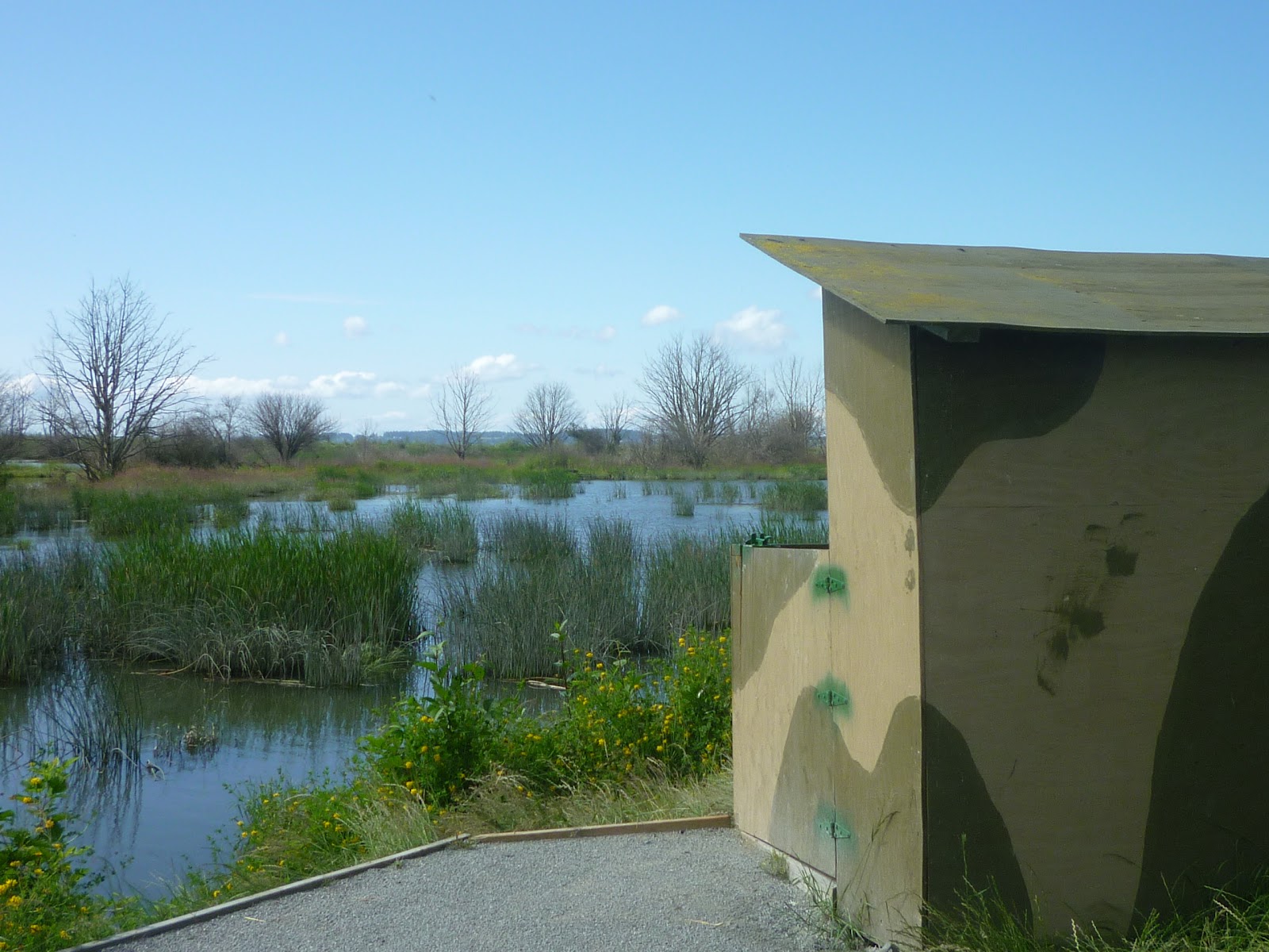
There are various hunting blinds along the way (is that what those things are called, the place where the hunters hide?). Posted along the way are many signs warning of hunting from September 1 - March 15. I'm not anti-hunting if hunters are providing food for their families, however it seems odd to me that we have a beautiful wildlife refuge, yet hunting  is allowed within the refuge. Especially considering that there are THOUSANDS of snow geese that come here, and snow geese mate for life. 


Looked like a place you'd buy nachos and candy at a Little League game.
This park was very clean. I saw only one piece of trash, which I picked up and brought home to throw away. I came across young families, nature photographers and seniors out walking. I was dismayed to see that I was the only one with my dog on a leash. A couple of dogs were under good voice control, but others were not. I do feel that because this is a wildlife refuge,allowing dogs to run loose and frighten the birds is less than desirable. 

Jack in front of the boat ramp aka dog cooling-off area
My GPS measured about 2.5 miles, but I wandered over to explore the covered area and the bulletin boards in the parking lot. According to the bulletin boards, there are plans to reclaim some of the lost area. I believe floods in years past altered the area quite a bit which probably explains the benches in the water. You do need a Discover Pass here. Be sure to bring your own doggy bags and be prepared to take them home with you., along with any trash as I didn't see any dispensers for doggy bags, nor any trash cans.
Looking northwest, the surrounding farmland is beautiful, too!


If you visit this location via I-5, you will pass this beautiful church in Conway. 
Driving directions from the WTA website ( www.wta.org ): 

Take Interstate 5 to Exit 221. Go west from the freeway and turn right on to Fir Island Road, following the sign for Conway/La Conner. In 1.8 miles, turn left onto Wylie Road and follow for 1 mile to a T-intersection and a Washington Department of Fish and Wildlife sign. Turn left and follow the signs to either of the two parking lots.

Sunday, July 1, 2012

Hike 8 of 47 - Orcas Island 25k

Moran State Park on Orcas Island in Eastsound, Washington
January 28, 2012

Please forgive my numbering, it's a little out of whack.

It was snowy, it was cold and I most definitely hadn't trained enough, yet here were were again, giddy with excitment, on the ferry headed to Orcas Island for our second Orcas Island 25k, one of the awesome trail runs put on by Rainshadow Running.  Moran State Park boasts an amazing trail system, with almost 40 miles of trails!  This year, rather than staying in the Group Camp facilities at Moran State Park, we were lucky enough to be staying at North Beach Inn thanks to one of our fellow trail runners. We were excited about showers, a little kitchen and beds that weren't 1966 metal bunk beds! It's the little things that mean so much.

Awesome thrift-shop shirts!
The night before the race, we checked in at the group camp, picked up our shirts, then settled in to our cabins and had a potluck dinner, which is always a good time with delicious food, lots of laughs and a couple of beers thanks to a beer run by Marie.

We rose early well before dawn, got dressed and headed over to the Start/Finish area.This 25k boasts 3,500' of elevation gain, old growth forest, waterfalls and beautiful views from the summit, provided the clouds haven't moved in and obscured the views. Add in the anticipated snow and ice and we were guaranteed a good time!


Someones idea of a good time!
We said goodbye to our friends then Kerrie and I, being hikers rather than runners, took an early start to ensure that we were well into the first climb toward Little Summit before the stampeding pack caught  and passed us.  We left  the Start/Finish line and followed the well-marked course onto Cascade Creek trail. This trail climbs up gently passing the spectacular Cascade Falls and several other smaller water falls. 


We continued on passing the Mountain Lake Dam and hiked along the west shoreline of the lake, which brought us to the Mountain Lake Parking area. From here we picked up the rather difficult Mount Constitution Loop trail and immediately started climbing. Initially this trail is very steep and it is here that the pack caught up with us. I did a lot of stepping off the trail to let the runners pass by. 

Lots of Douglas Fir and Western Hemlock trees in this area of Moran State Park. I read in the park brochure that this trail was initially a pathway for the telephone lines when crank telephones were used. Staying on this trail, we ignored the Little Summit trail which veered left and continued on upward following the orange tape toward the summit of Mount Constitution at 2,409'..


Less than one mile from reaching the actual summit, we came upon a clearing that afforded us some amazing views of the San Juan Islands. Last year the fog blocked our view, so Kerrie and I took a little break, snapped some photos and truly enjoyed the views. That is the true beauty of hiking, enjoying the AMAZING scenery around us, while doing something healthy with people you enjoy hanging out with.
Amazing views!

Kerrie celebrating!


After we left this area, headed for the actual summit less than a mile away, we were finally passed by the last of the runners. It was nice to know we could just hike our hike and not have to worry about slowing anyone down.  Here the snow got deep and our pace slowed.  Finally reaching the summit race aide station after climbing up the last icy hill, we took about a ten minute break and attempted to warm up. Once we stood still, it immediately became clear just how chilly it was! The wonderful volunteers fed us soup, wrapped my shoulders with a warm blanket and generally "mothered" us until we were so cold that walking was the only thing that would warm us us.  With just 7 miles, and a lot of elevation gain, under out belt, we were almost half way done. Together we battled our way across the very icy parking lot trying desperately to stay upright and picked up the trail that headed down.

There was a good bit of descent where I could pick up some time, and then another big climb to about 2,350'. I was feeling "DONE!"  at this point. Somewhere on the descent the trail "sweepers" caught up with us and stayed on our tails for the rest of the hike. It was a little unnerving to feel like I was holding people up, but they assured us that our pace was just fine.  I did the best I could and they were fun to talk to. One of them had a little dog in an argyle print jacket who was hiking, too!
 The second half seemed to pass slowly, but once we hit the major downhill with tons of switchbacks I felt like we were in the home stretch. We came down pass some gigantic trees and eventually ended up back at Cascade Lake, near the Day Use area. There was a great CCC restroom with my name on it!   After a quick potty stop, we crossed the road and followed a trail around the lake, where we were met by Ashley about 1/2 mile from the Start/Finish line. By this time, everyone else had finished, showered and had some warm soup and a cold beer while listening to some great music! 
The Start/Finish line when Kerrie & I arrived
My second Orcas Island 25k was now complete. I cut approximately 1.5 hours off my 2011 time in spite of tons of snow and ice. It was a fun way to burn several thousand calories and see some beautiful sights.  If you are ever in the area, check out Moran State Park; there is something for everyone!
Liz & Ashley


Wednesday, May 9, 2012

Hike 7 of 47 - Pilchuck Tree Farm

Hike 7 of 47 - Pilchuck Tree Farm in Stanwood, Washington


January 14, 2012 - I'm just getting around to finishing up this blog entry!
Pilchuk Glass School during a sunny, winter day (not the day of this hike!)


Northwest Washington was hit with a mammoth (for us) snowstorm mid-January that left our area with 6-18" of snow. So, we decided to go for a snowy hike/run in preparation for the Orcas Island 25 that was fast approaching. Kerrie, Ashley and I bundled up (a little) and headed to Stanwood for some brisk, snowy miles. We were accompanied by Jack, my German Shepherd and Oliver who is Ashley's Jack Russell Terrier. And if I may say so, Oliver looked quite dashing in his plaid coat.


Located near Pilchuck Glass Studio, Pilchuck Tree Farm is exactly what its' name implies: a tree farm. There are forested areas and clear-cut areas, logging roads and trails. The trails are used by hikers, joggers, mountain bikers and equestrians.  Oh, and loggers too, but fortunately I've never run into anyone working in my visits. On this very snowy day we saw what looked like hunters, but I don't know if they actually were hunting or just dressed the part. At Pilchuck, you are in and out of the trees. The trails tend to be on the muddy side, especially in the spring. 

There is a labyrinth of trails here and it's easy for me to get turned around and subsequently lost. This is where my GPS comes in extremely handy. I love this little gadget, not only for the normal GPS features like pace, speed, distance and calories burned, but at places like this I really like, and use, the "Out & Back" feature, that you can follow your exact route back to the starting point. Another feature is the "map" that allows me to see on a field exactly where I am and where I want to be. If the terrain permits and I'm short on time, I can amble in the right direction by watching the directional arrow on the GPS unit until I'm back at my car. Now, if there are mountains and bodies of water, you can skirt around them while still seeing your destination. There are miles and miles of trails here, that's I've only just begun to explore. Ashley knows her way around here fairly well, but on this day she would probably be doing a lot of running with some occasional hiking. Having the GPS would be important for Kerrie and I who were mostly hiking with a little jogging thrown in for fun. Fun? Did I just say jogging and fun in the same sentence?


Jack loves a snowy hike.
After donning our hats and gloves, Ashley, Kerrie, Jack, Oliver and I hit the snowy trails. The depth of the snow varied from 2" to 8", although some spots sure seemed like more than that! The snow makes hiking and jogging a super-duper cardio workout. Ashley was marking the trail with ribbons for our friends who wanted to run that loop. That meant she jogged a bit then stopped to tie a yellow ribbon round the old oak tree....oh wait....I got lost in an old 70's tune for a moment. She also put in some extra miles jogging ahead and then back to Kerrie and I.


Almost to the top, on the south side is a big clear cut. From here one can see Lake McMurray. While the views are beautiful, standing among the stumps isn't. I believe Whitehorse Mountain is visible from this vantage point on a more clear day. 
Looking southeast, approx. elevation 1,100'
Up at the top of the hill in the Pilchuck Tree Farm, which my GPS recorded as 1,402' elevation,  is a monument and a couple of benches. It provides fantastic views to the north in which you can see Conway, Mount Vernon, Anacortes and the San Juan Islands. It's also a great spot to take a break, have a snack or lay down in the beautiful meadow on a sunny day.
Monument at the top, looking north.
Time was running short and I had to get to work. We headed back down the trail, taking a slightly different route back to our cars. We arrived at our respective vehicles with cold hands and wet feet. This was a beautiful, invigorating hike that is close to home. I hope that we get some snow next winter so that I can find more snowy hikes. This is a place that I will definitely return to again to put in more miles.
Ashley & Kerrie


Me and Ashley


7 miles
3 hours
1,170 calories
830' elevation gain


Thursday, May 3, 2012

Hike 11 of 47 - Heart Lake in Anacortes, Washington

April 30, 2012
Heart Lake
Jack and I at the north end of Heart Lake


Today we crossed our fingers for decent weather and headed out to Heart Lake in Anacortes. There are some wonderful hikes in the Anacortes Community Forest Lands (ACFL) and we were on the hunt for an easy one as today was going to be the first day that my one year old grandson Oliver rode in a backpack. Up until now, he'd been carried in the frontpack. 
Something very interesting on the forest floor


The ACFL includes roughly 35 miles of multi-use trails. While you will see mostly hikers, horses and mountain bikes are allowed on some of the trails. For part of the year and only on some of the trails, motorcycles may be seen (or heard). Although, in the 3-4 years that I've been hiking here, I've only encountered motorcycles twice. Dogs are allowed on-leash. The trails are especially well marked and ACFL puts out a set of 3 great maps for the lakes the ACFL surround; Whistle Lake, Cranberry Lake and Heart Lake, which used to be Heart Lake State Park, but now belongs to ACFL. Maps are available at several locations around town.


Ms Mammary Monkey relaxing on a VERY large leaf
We parked at the Heart Lake parking lot (where there are two restrooms and lots of fishermen putting their little boats into the water) and loaded up the kiddo in his backpack. 


My daughter, Oliver and I set on on our hike, while my son-in-law took off on his mountain bike. The weather was cloudy initially, it brightened up as our hike went on. We left the parking lot headed north on Trail 210 which goes around approximately 2/3's of the war around the lake in in a counter-clockwise direction. We passed several intersecting trails, but continued on 210 until its end passing several thick-barked, beautiful old Douglas Fir trees which had obviously been involved in a forest fire sometime long ago. 


At that point we had to make a decision; continue south about 1.5 miles to a viewpoint or loop back around to the parking lot taking a different route back. Since we weren't really sure how the view would be on this cloudy day or how much time we had before we met up with my mountain biking son-in-law, we opted to head back around the lake, taking a different route. From there we headed east on Trail 212 and north on Trail 250, picking up Trail 210 clockwise and then 242 back to the parking lot.  


As I mentioned, the trails are well marked with views are of the lake and forest. Lots of time for picture taking and we took a lot of pictures! 


If you get to the southern viewpoint, you can see south toward Deception Pass with beautiful water views. The trails to the south of the lake are designated for hikers only. There was a fair bit of mud on the trails, not terrible, just mildly annoying. It rained hard the night prior so mud was to be expected. 


It was just a little muddy on this day


We didn't pass any hikers, but did pass a man and his dog, who looked like they were headed to their favorite fishing spot. 


A quick glance at the Heart Lake map tells me that there are approximately 10 miles of trails surrounding this lake. There is ample parking which is on the east side of the lake, off Heart Lake Road, which is actually H Street in Anacortes. All of the trails around Heart Lake are great for kids of all ages as the elevation gain is minimal and there are restrooms in the parking lot. Hillary, Oliver and I walked 4 miles in two hours and had a total elevation gain of about 550'. If you haven't made it out to these trails, put it on your list for a day hike. You can make it as long or short as you like. You can walk across the street from Heart Lake and hike up to the top of Mount Erie the very same day. From up there at just under 1,300' the view is amazing! 


Ariolimax columbianus  or Banana Slug
All in all, it was a successful day for Oliver's first hike in his backpack! He is fortunate to grow up in such a beautiful area of the country. I think we have a junior hiker in the making!


Hiking is hard work!


Distance:  4.1 miles
Time:  2 hours
Calories burned:  750

Monday, April 30, 2012

Hike 10 of 47 - WTA Volunteer Trail Work at Lost Lake

Hike 10 of 47 - Lost Lake Trail - volunteer trail work

The view from Lost Lake Trail


This past Saturday, April 28th,  Julie and I, along with 40 other like-minded individuals participated in a Washington Trail Association trail work event on the Lost Lake Trail in the Chuckanuts. If you aren't familiar with WTA and you love hiking in Washington, you should quickly familiarize yourself with them. It's a wonderful organization committed to providing accurate hiking info, trail reports, photos, and much more.

Although we only hiked about 3.5 miles in 6 hours, we worked hard shoveling, digging, clearing trails of duff and improving drainage.  It was a great was to spend a sunny Saturday!


This particular work party also happened to be sponsored by REI in Bellingham. All volunteers received a voucher for a T-shirt and a chance to win a pair of binoculars donated by REI.

The day started out with a brief meeting in which Arlon, the Crew Leader, reviewed the 3 rules of the day:

1) SAFETY FIRST! We all came dressed for safety; in semi-official Trail Geek fashion which consisted of long pants, long sleeved shirt, hiking boots and gloves.  I don't have any suspenders, but I think I'll get some because my pants kept slipping down, which is most definitely NOT a good look.  WTA provided snazzy green hard hats and instructions on how to use each piece of equipment. We also identified those in the group who had First Aid kits and when asked if anyone in the group had medical training, well.....Of course, being the medical professionals that Julie and I are, I offered up our services should anyone decide to have a baby during the work party. Safety first people, DO NOT go into labor on the trail!

Julie & Liz 

2) GET SOME WORK DONE. The various crew leaders explained the goals for the day and everyone. We would be working the length of the Lost Lake Trail, which was in desperate need for some drainage work. People could decided how far up the trail they wanted to go. Keep in mind, we were also carrying our day packs and the equipment. Oh, and Ms. Mammary Monkey came along to help, too.


3)  HAVE FUN!!   It was stressed that this day was to be fun and if someone wasn't having fun, then that situations would need to be rectified. I must say, it was tons of fun!
Brad, Julie, Kriss and I after much fiddling with the camera and me falling in the stinging nettles!

WTA is fabulous at encouraging people to work at their own pace, take breaks when needed and to look out for one another. I worked with equipment I had used in the past, such as a shovel and a hand saw. Some things that were new to me were the Pulaski,  Grub Hoe and McLeod, which I learned can easily leave someone with 6 sucking chest wounds if safety isn't #1. I developed a whole new respect for those who are carrying these tools for days on end out in the backcountry fighting forest fires.


 It felt good to get out there an use muscles that I don't use every day. I also learned a very important lesson:  a hard hat sitting at trails edge, usually means someone has discretely stepped off the trail to go potty, so do not pick up the "lost" hard hat and try to find its owner. After 5 volunteer days, WTA presents the volunteer with his/her very own WTA hardhat. I can't wait to get one!

We met Pete, who was our immediate Crew Leader. Pete was a pretty amazing guy. He's 82, a retired lawyer and has done well over 1,000 trial work volunteer days. He said he stopped counting long ago.  When we sat down to lunch, he shared some stories of his growing up years in Texas.  Lots to be learned by listening to folks like Pete.

Pete, Brad & Julie - lunch break

I worked with a gentleman named Kriss. It was fun to make new friends who share common interests. Julie worked with Brad, who was working on his 25th volunteer day. The four of us leap-frogged with each other all day, completing various projects all aimed at diverting water off the the trail. We cleared a fallen tree out of a drainage area, removed debris, dug a catch basin to allow water to flow into a culvert. Below is our big project of the day. It doesn't seem like much, but this area is about 25-30 feet long and was filled with a lot of stuff. Much time was spent swatting mosquito's and spraying ourselves with DEET. The annoying little suckers were surprisingly thick this day. I've never encountered many bugs at all up in this area.

My largest project of the day - clearing the drainage and digging a catch basin

There are lots of opportunities to get out and enjoy some fresh air. WTA has many Trail Work Parties scheduled throughout the state. There are single day trips, 3 day trips, Youth Trail Work Parties, Youth Vacations and even some Volunteer Vacations which last for one full week. Check out the schedule; there is bound to be something that interests you.  Some governmental agencies offer vouchers in exchange for trail work. Once you've worked 24 hours, the vouchers can be exchanged for a Discover Pass.

All in all, it was a great day! We hiked a little, met some great people, gave something back to the trails we so enjoy, worked hard, got some exercise and laughed a lot. If you want more information, check out the Common Questions.  As for me, I'm hooked on volunteer trail work!

If you enjoy the wonderful trails we have here in Washington, please consider joining WTA for a Volunteer Trial Party; you won't regret it.